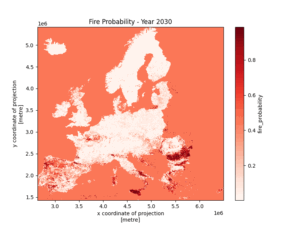
Alpha-Klima Wildfire Risk v1.0
– Date: 28 March 2025
– Version: 1.0
– Status: Public release to OS-Climate
– Changes: Initial publication of high-resolution wildfire risk projection dataset for Europe (2001–2050; Scenarios: Historical, RCP4.5, and RCP8.5)
1. Introduction & Alignment with Previous Research
Alpha-Klima Wildfire Risk v1.0 provides high-resolution annual wildfire occurrence probabilities at 2.5 km × 2.5 km (EPSG:3035) for Europe from 2001 through 2050. It leverages a constrained XGBoost classification framework informed by Burger et al. (2024), incorporating:
- Meteorological Indicators: Means and Maximum of the Fire Weather Index (FWI) from Copernicus.
- Land Surface Predictors: Annual MODIS land cover data.
- Anthropogenic Features: Road, railway, and urban-area proximity from harmonized datasets and OpenStreetMap sources.
Key Similarities to Burger et al. (2024)
This dataset has been developed following the guidelines of:
- Single-step wildfire occurrence modeling rather than multi-stage burnt-area/duration models.
- Constrained gradient boosting for more explainable results (i.e., monotonic relationship with critical predictors like FWI).
- 2.5 km resolution covering Europe.
- Historical calibration (2001–2022) plus forward-looking scenario analysis (2023–2050).
- Explainability emphasis: Partial dependence plots demonstrate how changes in FWI, cropland share, and distance to roads affect fire probability.
New in Alpha-Klima v1.0
- Additional Urban Data: Incorporating urban extent from OpenStreetMap to refine ignition-risk factors near population centers.
- Exclusion of some countries: The HARCI-EU dataset does not include Turkey, so Turkey is excluded from the analysis.
2. Methods
2.1 Model Inputs & Preprocessing
- Meteorological Drivers (FWI):
– Primary input from the Copernicus Climate Data Store.
– Historical (2001–2006) plus RCP4.5 and RCP8.5 climate-projection FWI up to 2050.
– Mean and maximum FWI. - Land Cover:
– Annual MODIS Land Cover (MCD12Q1), 500 m upscaled to 2.5 km.
– Forest, cropland, grassland, and urban categories. Fractional cover computed using histogram aggregation. - Anthropogenic & Socioeconomic:
– Distance to nearest road, railway, and urban area.
– Derived from HARCI-EU plus open-access geospatial sources.
– Monotonic constraints reflect that closer proximity generally increases ignition risk. - Historical Fire Observations:
– NASA MCD64A1 burned-area data used to generate yearly binary “fire occurrence” labels (2001–2023). - Grid Harmonization:
– All inputs aligned to a common 2.5 km × 2.5 km resolution (crs EPSG:3035).
– Missing values imputed by nearest-neighbor filling.
2.2 Modeling Approach
- Single-Step Wildfire Occurrence: The target is a 0/1 label indicating at least one wildfire in a grid cell per year.
- Gradient Boosting with Monotonic Constraints: – Implemented via XGBoost with constraints to ensure physically/intuitively consistent relationships (e.g., higher FWI cannot lower predicted fire probability).
2.3 Bias Correction & Scaling
- Static Inputs beyond 2023: Land cover and infrastructure remain unchanged for future years.
- Interpolation & Resampling:
– Bilinear interpolation for continuous variables (e.g., FWI).
– Majority or nearest-neighbor filters for categorical land cover.
3. Scenario Outputs & Caveats
Historical (2001–2023):
Baseline rates derived from NASA MCD64A1.
Model evaluated extensively to match observed spatiotemporal patterns.
Forward-Looking (2024–2050):
RCP4.5 & RCP8.5 FWI projections from Copernicus.
Results indicate overall increasing fire probability in southern and parts of central Europe, with localized decreases in more humid regions.
Known Limitations:
- Exclusion of Turkey: HARCI-EU dataset does not provide coverage for Turkey.
- Static Land Cover: Real-world changes (e.g., afforestation) are not captured for scenario analysis.
- Infrastructure Assumption: Road/urban footprints remain static for 50 years.
- Scenario Scope: Only RCP4.5 and RCP8.5 are included.
4. Datasets Used
- Fire Weather Index (FWI)
– Source: Copernicus Climate Data Store (C3S).
– Usage: Maximum and mean yearly data used.
– CDS - Burned Area History
– Source: NASA FIRMS (MODIS MCD64A1).
– Usage: Binary labeling of fire occurrence per grid cell per year.
– NASA FIRMS - Land Cover Classification
– Source: MODIS MCD12Q1.
– Usage: Annual land cover categories for vegetation-fuel modeling.
– MODIS Land Cover - Critical Infrastructure
– Source: HARCI-EU plus public open datasets (OpenStreetMap).
– Usage: Road, railway, and urban proximity as ignition-risk proxies.
– HARCI-EU
5. Licensing & Attribution
License: Published under CC-BY 4.0
Citation:
Alpha-Klima (2025). Wildfire Risk for Europe under RCP4.5 and RCP8.5: 2001–2050 (v1.0). DOI:10.5281/zenodo.15123977
6. Contact
Alpha-Klima Team
Calle José Bardasano Baos 9, 7ºAB, 28016 Madrid, Spain


Deja tu comentario