
Case study ·
Fluvial inundation in Seville: Climate trends, exposure and the insurance gap
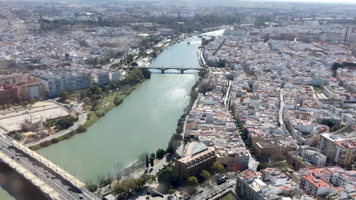
Alpha-Klima analysed fluvial flood risk across the Spanish city of Seville, combining forward-looking hazard data with exposure and vulnerability modelling to assess potential impacts on insurance portfolios.
The analysis shows why physical climate risk cannot be inferred from proximity to a river alone. Postcodes in the historic centre (41003) and the Macarena district (41008) show higher flood exposure than some areas located physically closer to the Guadalquivir basin. Under an adverse climate scenario, risk in some of the most climate-sensitive districts could increase by up to 65% by 2035 relative to the historical baseline.
Key insights
- Forward-looking fluvial flood-risk analysis of Seville’s residential stock at postcode level.
- Climate change could materially alter the spatial distribution and magnitude of risk beyond what historical claims data captures.
- Exposure estimates combine hazard, vulnerability, geolocation and property-value data at a level compatible with typical insurance portfolio information.
- The analysis translates physical risk into an aggregated Solvency Capital Requirement (SCR) view using a 99.5% Value-at-Risk.
- Spain’s Consorcio de Compensación de Seguros provides an important protection mechanism, but does not eliminate the insurance gap or the need to understand how underlying risk may evolve.
The challenge for insurers
Fluvial flooding is one of the most material physical risks across Europe, and climate change may increase both its probability and potential consequences. Spanish public authorities explicitly recognise this shift, which could translate into higher claims, affordability pressures and reduced insurance availability in highly exposed areas.
For insurers, the challenge is that flood risk can no longer be assessed solely through historical claims data, as changes in flood frequency, severity and spatial distribution may alter the risk profile of existing portfolios over time. Historical claims data therefore needs to be complemented by forward-looking analysis across possible future climate scenarios.
In 2023, the German Insurance Association (GDV) highlighted that rising climate-related claims costs could materially increase property insurance premiums over the following decade, with some scenarios pointing to a potential doubling. EIOPA has similarly raised concerns that, in highly exposed areas, natural-catastrophe coverage may become increasingly difficult to maintain in terms of both availability and affordability.
The objective is therefore to understand how today’s exposures may behave under future climate conditions, rather than relying exclusively on past loss experience.
Seville as a case in point
In this context, Seville represents a particularly relevant and timely case. In February 2026, storm Leonardo caused the Guadalquivir River to overflow in several areas of Andalusia, forcing the evacuation of thousands of people and highlighting the exposure of certain locations to flood risk.
Seville also stands out among major Spanish cities in terms of flooding susceptibility, as it combines significant urban development with exposure to the Guadalquivir river system and considerable variation in topography, building density and property values across districts. Various estimates suggest that a significant share of its residential stock could be affected by high return-period flood events, reinforcing the case for granular and forward-looking assessment.
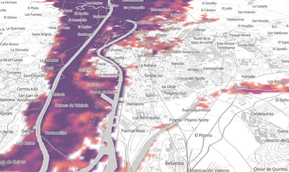
The figure below shows an example of the flood-risk map available in the Alpha-Klima platform for the Seville area. High-resolution hazard data can be combined with asset-specific vulnerability models to move from a geographic representation of flooding towards an estimate of potential financial impact, both at individual asset level and across insurance portfolios exposed to the city.
How geographic resolution and data uncertainty affect risk assessment
Precise asset coordinates are not always available in insurance datasets, and exposure information may be recorded at different levels of geographic detail across systems. This matters because the quality and granularity of exposure data determine how precisely physical risk can be assessed.
A practical approach is to align the resolution of the risk analysis with that of the available exposure data. Aggregating geographic information at postcode level, for example, provides a pragmatic starting point. It allows insurers to identify concentrations of exposure, support territorial prioritisation and accumulation analysis, and highlight areas where a more detailed assessment may be warranted.
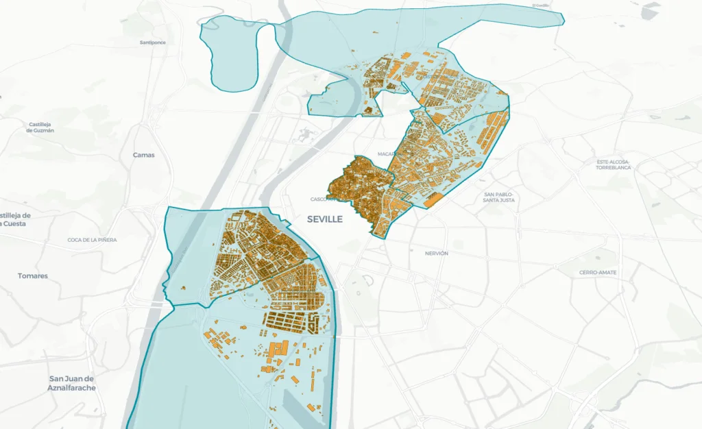
By combining building geolocation data from OpenStreetMap with market price data per square metre across different areas of Seville [1], Alpha-Klima constructed a first-order estimate of exposure value to flood risk at postcode level. The resulting proxy reflects not only the presence of buildings in flood-prone areas, but also differences in the value and concentration of the assets exposed.
[1] Market price data was obtained from Idealista.
The map below shows the five postcodes with the highest estimated exposure to flood risk in the city of Seville. One of the most relevant findings is that postcodes in the historic city centre (41003) and the Macarena district (41008) exhibit higher levels of exposure than some postcodes located closer to the river. This illustrates the importance of considering not only proximity to the hazard, but also local topography and the distribution and value of exposed assets.
A forward-looking view of capital requirements
The analysis also evaluates how the Solvency Capital Requirement (SCR) associated with these exposures could evolve up to 2035 under the unfavourable Hot-House World climate scenario.
The methodology incorporates physical factors such as river-basin topography, which influences the propagation and accumulation of flood waters, as well as the spatial dependence of flood risk. Risk aggregation is performed using copula-based techniques to reflect full dependence between assets within the same postcode. This allows an aggregated impact distribution to be constructed at postcode level, from which the SCR is derived as the 99.5% Value-at-Risk (VaR), in line with Solvency II standards.
This approach captures potential loss concentration under extreme scenarios and reduces the risk of understating aggregated exposure in portfolios affected by the same flood event.
The comparison between the historical baseline and the adverse scenario to 2035 shows that the historic centre and Macarena stand out not only because of their current exposure levels, but also because of the projected increase in risk over the coming decade.
Other postcodes, while not among the most exposed in absolute terms, show particularly high sensitivity to climate change. In areas such as La Buhaira and San Pablo–Santa Justa, exposure to fluvial flood risk could increase by up to 65% relative to the historical baseline.
The results therefore distinguish between two related but different questions: where flood risk is concentrated today, and where it may increase most significantly under future climate conditions.
The insurance gap and the Spanish Consorcio de Compensación de Seguros
The Spanish insurance market has a distinctive feature: the Consorcio de Compensación de Seguros (CCS), Spain’s public insurance compensation scheme. Fluvial flooding is classified as an extraordinary risk, meaning that the Consorcio, rather than private insurers, is responsible for compensating damages provided that a valid insurance policy is in place within the relevant lines of business.
This public-private arrangement adds an important layer of protection against natural disasters and contributes to the resilience of the Spanish insurance system. It does not, however, eliminate the insurance gap.
That gap is not limited to assets with no insurance coverage. It can also arise where existing protection is insufficient relative to the underlying risk, where exposure is not adequately understood or located, or where losses fall outside the effective scope of coverage.
In Spain, the requirement for an underlying insurance policy is particularly relevant: assets that are not insured in the first place remain outside the Consorcio mechanism.
The presence of the CCS therefore changes the way flood risk is absorbed, but not the need to understand how that risk is evolving. For both insurers and supervisors, this means assessing changes in severity, frequency and concentration of exposure and considering how they may affect underwriting, portfolio management, affordability and insurability over time.
Reducing the insurance gap is therefore not only a question of extending coverage, it also requires a clearer understanding of the underlying risk. Combining forward-looking hazard information with more granular exposure data can help insurers identify emerging concentrations, anticipate portfolio pressures and support a more resilient insurance system.
Data sources
- Paprotny, D. and Morales Nápoles, O. (2016), Pan-European data sets of river flood probability of occurrence under present and future climate, 4TU.ResearchData – the flood-hazard layer behind the maps above.
- OpenStreetMap – building geolocation. Market prices per square metre from Idealista.
At Alpha-Klima, we help insurers turn physical climate risk into traceable, portfolio-relevant analysis by linking hazard, vulnerability, impact and aggregation into outputs that support underwriting, risk management and reporting.